|
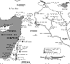 |
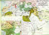
Map of ancient sites of the Middle East. Many ancient
civilizations existed on the Syrian soil. This map displays some
of the ancient sites in Syria and the Middle East.
خريطة المواقع الأثرية في الشرق الأوسط . عدة مواقع حضارات قامت
على الاراضي السورية. وهذه الخرطة تعرض المواقع الاثرية في سورية
والشرق الأوسط
----------------------------------------------------------------------------------------------------------------------- |
|
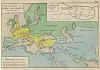 |
Map of the Great Umayyad Empire, with a small map of its
capital, Damascus. This empire was the greatest in the world in
the 7th and 8th centuries under Caliph Walid I. The map dates
back to 1884
خرطة تبين الامبراطورة الاموية العظيمة بالاضافة إلى خريطة مصغرة
لعاصمتها " دمشق"
وقد كانت أعظم امبراطورية في العالم في القرنين السابع والثامن تحت
خلافة الوليد ويعود تارخ هذه الخريطة لعام 1884
----------------------
------------------------------------------------------------------------------------------------
|
|
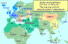 |
Another map of the Umayyad Empire at its greatest extent.
آخر خرطة للامبارطورية الاموية في مداها الأعظم |
|
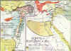 |
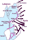
The Crusaders Principalities in Syria and Palestine and the
Empire of Saladin, who defeated the Crusaders at the battle of
Hittin
الممالك الصليبية في سوريا وفلسطين وإمباطورية صلاح الدين الذي هزم
الصليبيين في معركة حطين |
|
 |
The Ottoman Empire (16th and 17th centuries). The Ottomans
occupied the Middle East including Syria in 1516. Their
occupation lasted till 1918.
الامبراطورية العثمانية (في القرن السادس والسابع عشر ). أحتل
العثمانيون الشرق الأوسط ومن ضمنهم سوريا في عام 1516م واستمر هذا
الاحتلال حتى عام 1918 |
|
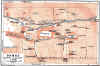 |
The city of Damascus, 1912. From a guide book on "Palestine and
Syria".
خريطة تاريخية لمدينة دمشق عام 1912(مأخوذة من كتاب مرشد سوريا
وفلسطين) |
|
 |
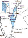
1947 UN Partition plan for Palestine. The plan gave the Jewish
state 58% of Palestine's area despite the fact that Jews were
only 30% of Palestine's population.
وفي عام 1947وضعت الامم المتحدة خطة لتقسيم فلسطين . الخطة أعطت
اليهود 58% من الاراضي الفلسطينية رغم أنه في الحقيقة كانت نسبة
اليهود لاتزيد عن 30%من سكان فلسطبن |
|
 |
The Arab armies attack in the Palestine War 1948. Arabs achieved
initial victories. Before accepting a short truce, during which
Israel strengthened its troops with new weapons.
هاجمت الجيوش العربية في حرب فلسطين عام 1948حقق فيها العرب
انتصارات أولية قبل إعلان الهدنة التي استطاعت من خلالها اسرائيل
من تعزيز قوها إضافة إلى حصولها على أسلحة جديدة |
|
 |
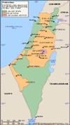
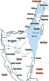
Armistice lines 1949. The war ended with Israel occupying 78% of
Palestine. But the Arab-Israeli conflict was only at its
beginning.
خطوط الهدنة عام 1949. أنتهت الحرب بعد احتلال اسرائيل نسبة 78%من
الأراضي الفلسطينية ولكن الصراع بين العرب واسرائيل كان مجرد بداية
ليس إلا . |
|
 |
Israeli aggression against Arab countries, June 1967. During a
six-day-war, Israel occupied Egyptian Sinai, the West Bank of
Jordan and the Syrian Golan Heights.
العدوان الإسرائيلي على الدول العربية ، حزيران 1967. خلال ستة
ايام من الحرب
احتلت اسرائيل سيناء المصرية والضفة الغربية من الاردن وهضبة
الجولان السورية
.
|
|
 |
Syrian attack in the Golan Heights during the October War 1973.
Syrians were only few kilometers away from the Sea of Galilee.
Israel would have suffered a disastrous defeat without the
massive American military aid. |
|
 |
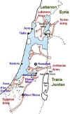
Golan Heights (1974-1999), After the October War 1973, Syria
liberated some land in the Golan. This is how the Golan looks
today, with many Israeli settlements built in it against all
international laws and UN resolutions. |